Parsa District
Parsa District (Nepali: पर्सा जिल्ला Listen , a part of Madhesh Province in Terai plain, is one of the seventy-seven districts of Nepal. The district, with Birgunj as its district headquarters, covers an area of 1,353 km2 (522 sq mi) and has a population (2001) of 497,219. According to the locals, Parsa is named after Parashnath temple situated in Mahuwan.
Parsa District
पर्सा जिल्ला | |
|---|---|
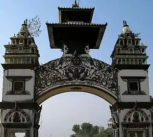 The gate in Birganj on the Indo-Nepal border | |
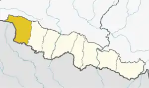 Location of Parsa District (dark yellow) in Madhesh Province | |
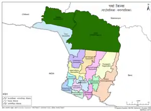 Parsa District with local level body | |
| Country |  Nepal Nepal |
| Province | Madhesh Province |
| Established | During Rana regime |
| Admin HQ. | Birgunj |
| Local level body | List
|
| Government | |
| • Type | Coordination committee |
| • Body | DCC, Parsa |
| • Head | Nek Muhammad Ansari |
| • Deputy-Head | Thakur Prasad Neupane |
| • Parliamentary constituencies | 4 (List) |
| • Provincial constituencies | 8 |
| Area | |
| • Total | 1,353 km2 (522 sq mi) |
| Population (2011) | |
| • Total | 601,017 |
| • Density | 440/km2 (1,200/sq mi) |
| • Households | 95,516 |
| Demographics | |
| • Ethnic groups | Muslim, Kurmi, Tharu, Yadav |
| • Female ♀ | 48% |
| • Male ♂/100 female | 108.21 |
| Human Development Index | |
| • Income per capita (US dollars) | $1223 |
| • Poverty rate | 36.37 |
| • Literacy | 56% |
| • Life Expectancy | 70.25 |
| Time zone | UTC+05:45 (NPT) |
| Postal Codes | 44301... 44315 |
| Telephone Code | 051 |
| Main Language(s) | Bhojpuri (78.1%), Nepali (6.4%), Maithili (5.1%), Tharu (3.8%), Urdu (2.2%), others (4.4%) |
| Website | dccparsa |
Etymology
According to locals, the name of the district is derived from the Parsagadhi fort, where the Nepali Gorkhali Soldiers defeated British Soldiers.[3]
Geography and Climate
| Climate Zone[4] | Elevation Range | % of Area |
|---|---|---|
| Lower Tropical | below 300 meters (1,000 ft) | 74.7% |
| Upper Tropical | 300 to 1,000 meters 1,000 to 3,300 ft. |
25.3n% |
Demographics
At the time of the 2011 Nepal census, Parsa District had a population of 601,017. Of these, 78.1% spoke Bhojpuri, 6.4% Nepali, 5.1% Maithili, 3.8% Tharu, 2.2% Urdu, 1.3% Tamang, 0.8% Rajasthani and 0.7% Newari as their first language.
30.4% of the population in the district spoke Nepali, 5.4% Bhojpuri and 4.9% Hindi as their second language.[5]
| Census year | Pop. | ±% p.a. |
|---|---|---|
| 1981 | 284,338 | — |
| 1991 | 372,524 | +2.74% |
| 2001 | 497,219 | +2.93% |
| 2011 | 601,017 | +1.91% |
| 2021 | 649,397 | +0.78% |
| Source: Citypopulation[6] | ||
Notable people
- Ajay Chaurasiya - Nepali Congress leader, former minister and former Member of House of Representatives/Constituent Assembly
- Ajay Kumar Dwivedi - Nepali Congress leader and Member of Constituent Assembly
- Mohammad Lalbabu Raut Gaddhi - First Chief Minister of Madhesh Province
- Om Prakash Sharma - Nepali Congress leader, member of provincial assembly and Minister of Energy and Water Supply of Madhesh Province
- Pradeep Yadav - Suspended leader of PSP-N and member of House of Representatives
Administration
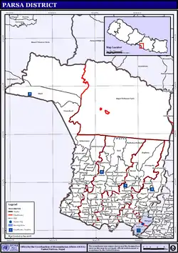
VDC/s and Municipalities (blue) in Parsa District The district consists of one metropolitan city, three urban municipalities and ten rural municipalities. These are as follows:
- Birgunj Metropolitan
- Bahudarmai Municipality
- Parsagadhi Municipality
- Pokhariya Municipality
- Bindabasini Rural Municipality
- Dhobini Rural Municipality
- Chhipaharmai Rural Municipality
- Jagarnathpur Rural Municipality
- Jirabhawani Rural Municipality
- Kalikamai Rural Municipality
- Pakaha Mainpur Rural Municipality
- Paterwa Sugauli Rural Municipality
- Sakhuwa Prasauni Rural Municipality
- Thori Rural Municipality
Former Village Development Committees (VDCs) and municipalities
References
 |
Wikimedia Commons has media related to Parsa District. |
- "NepalMap profile: Parsa".
- http://www.npc.gov.np/human_development_indicators_by_district/
- "नेपालीले अंग्रेजलाई हराएको पर्सागढी ओझेलमा". Online Khabar. Retrieved 2021-01-02.
- The Map of Potential Vegetation of Nepal - a forestry/agroecological/biodiversity classification system (PDF), Forest & Landscape Development and Environment Series 2-2005 and CFC-TIS Document Series No.110., 2005, ISBN 978-87-7903-210-1, retrieved Nov 22, 2013
- 2011 Nepal Census, Social Characteristics Tables
- "NEPAL: Administrative Division". www.citypopulation.de.
- "Districts of Nepal". Statoids.
Places adjacent to Parsa District | |
|---|---|


Headquarter: Birgunj | ||
| Metropolitan City | | |
| Municipalities | ||
| Rural municipalities | ||