Mauricie
Mauricie (French pronunciation: [mɔʁisi]) is a traditional and current administrative region of Quebec. La Mauricie National Park is contained within the region, making it a prime tourist location. The region has a land area of 35,860.05 km² (13,845.64 sq mi) and a population of 266,112 residents as of the 2016 Census.[1] Its largest cities are Trois-Rivières and Shawinigan.
Mauricie | |
|---|---|
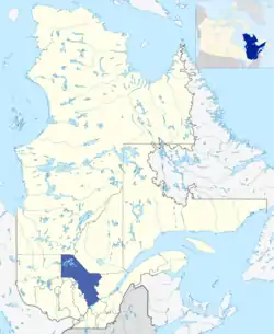 | |
| Coordinates: 47°00′N 73°00′W | |
| Country | .svg.png.webp) Canada Canada |
| Province |  Quebec Quebec |
| Regional County Municipalities (RCM) and Equivalent Territories (ET) | 3 RCM, 3 ET |
| Government | |
| • Table des élus de la Mauricie (Regional conference of elected officers) | Gérard Bruneau (President) |
| Area | |
| • Land | 35,860.05 km2 (13,845.64 sq mi) |
| Population | |
| • Total | 266,112 |
| • Density | 7.4/km2 (19/sq mi) |
| • Change 2011-2016 |  1.0% 1.0% |
| Time zone | UTC-5 (EST) |
| • Summer (DST) | UTC-4 (EDT) |
| Postal code | |
| Area code | 819, 873 |
| Website | www |
The word Mauricie was coined by local priest and historian Albert Tessier and is based on the Saint-Maurice river which runs through the region on a North-South axis.
Mauricie administrative region was created on August 20, 1997 from the split of Mauricie–Bois-Francs administrative region into Mauricie and Centre-du-Québec.[2] However, the concept of Mauricie as a traditional region long predates this.
Subdivisions
Regional County Municipalities
- Les Chenaux Regional County Municipality
- Maskinongé Regional County Municipality
- Mékinac Regional County Municipality
Equivalent territories
- Agglomeration of La Tuque
- Shawinigan
- Trois-Rivières
Independent municipalities
Major communities
School districts
10 Francophones:
- Centre de services scolaire du Chemin-du-Roy:
- Trois Rivières (3 districts)
- Maskinongé and
- Francheville.
- Centre de services scolaire de l'Énergie:
- Shawinigan (2 districts),
- La Tuque,
- Mékinac and
- Maskinongé.
Part of Anglophone:
Notable people
- Moïsette Olier (1885–1972), writer
- Jacques Plante (1929–1986), ice hockey goaltender
References
- "Census Profile, 2016 Census Mauricie [Economic region], Quebec". Statistics Canada. Retrieved November 22, 2019.
- "Modifications aux municipalités du Québec" (PDF). Bureau de la statistique du Québec. August 1997. ISSN 0843-8250. Retrieved 2012-05-20.
- "(Code 2470) Census Profile". 2011 census. Statistics Canada. 2012.
External links
 |
Wikimedia Commons has media related to Mauricie. |
 |
Wikivoyage has a travel guide for Mauricie. |
- Portail de la Mauricie Official website
- Tourisme Mauricie Regional tourist office
- CRÉ
Places adjacent to Mauricie | |
|---|---|


| Regional county municipalities and equivalent territories | |
|---|---|
| Municipalities | |