Verdon (river)
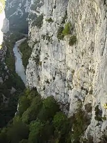
The Verdon (French pronunciation: [vɛʁdɔ̃], Occitan: [ˈbeɾðu]) is a 166.5-kilometre-long (103.5 mi) river in south-eastern France, left tributary of the Durance.[1] Its drainage basin is 2,295 km2 (886 sq mi).[2] The Verdon is best known for its impressive canyon: the Verdon Gorge. This limestone canyon, also called the "Grand Canyon of Verdon", 20 kilometres (12 mi) long and more than 300 metres (980 ft) deep, is a popular climbing and sight-seeing area. The name comes from the green appearance of the waters of the river, in the canyon.
| Verdon | |
|---|---|
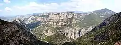 A view from the Verdon Gorge | |
 | |
| Location | |
| Country | France |
| Physical characteristics | |
| Source | |
| • location | Alpes-de-Haute-Provence |
| • elevation | 2,819 m (9,249 ft) |
| Mouth | |
• location | Durance |
• coordinates | 43°43′6″N 5°44′54″E |
| Length | 166.5 km (103.5 mi) |
| Basin size | 2,295 km2 (886 sq mi) |
| Basin features | |
| Progression | Durance→ Rhône→ Mediterranean Sea |
| Tributaries | |
| • left | Artuby |
Course
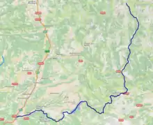
Its source is at an elevation of 2,819 metres (9,249 ft), in the southwestern Alps (Alpes-de-Haute-Provence), between the col d'Allos and the Trois Eveches mountain, south of Barcelonnette. It flows south-west through the following départements and towns:

The Verdon flows through several artificial lakes, before flowing into the river Durance near Vinon-sur-Verdon, south of Manosque.
Its main tributaries are the Artuby, Colostre, Jabron and Issole.[1]
See also
References
- Sandre. "Fiche cours d'eau - Le Verdon (X2--0200)".
- Bassin versant : Verdon (Le), Observatoire Régional Eau et Milieux Aquatiques en PACA
 |
Wikimedia Commons has media related to Verdon River. |