Touch (river)
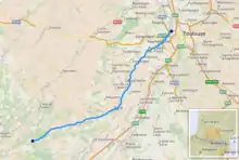
The Touch (French pronunciation: [tuʃ]; Occitan: Toish) is a 74.5 km (46.3 mi) long river in southwestern France, left tributary of the Garonne.[1] Its source is in the département of Haute-Garonne, near Lilhac.
| Touch | |
|---|---|
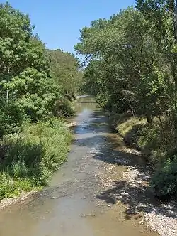 The Touch at Plaisance-du-Touch | |
 | |
| Location | |
| Country | France |
| Physical characteristics | |
| Source | |
| • location | Plateau de Lannemezan |
| • coordinates | 43°17′01″N 0°48′45″E |
| • elevation | 350 m (1,150 ft) |
| Mouth | |
• location | Garonne |
• coordinates | 43°37′22″N 01°24′01″E |
• elevation | 130 m (430 ft) |
| Length | 74.5 km (46.3 mi) |
| Basin size | 515 km2 (199 sq mi) |
| Discharge | |
| • average | 3.92 m3/s (138 cu ft/s) |
| Basin features | |
| Progression | Garonne→ Gironde estuary→ Atlantic Ocean |
It flows through the following départements and towns:
- Haute-Garonne: Bérat, Lherm, Plaisance-du-Touch, Tournefeuille, Blagnac, Toulouse.
References

This article is issued from Wikipedia. The text is licensed under Creative Commons - Attribution - Sharealike. Additional terms may apply for the media files.