New Brunswick Route 375
Route 375 is a 5.4-kilometre (3.4 mi) long east–west secondary highway in the northwest portion of New Brunswick, Canada.
 | ||||
|---|---|---|---|---|
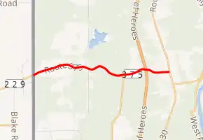 | ||||
| Route information | ||||
| Maintained by New Brunswick Department of Transportation | ||||
| Length | 5.4 km[1][2] (3.4 mi) | |||
| Major junctions | ||||
| East end |  Route 130 in Lower Portage Route 130 in Lower Portage | |||
| West end | US Border at the Gillespie Portage becomes  SR 229 SR 229 | |||
| Location | ||||
| Country | Canada | |||
| Province | New Brunswick | |||
| Highway system | ||||
| ||||


The route's northeastern terminus is in the community of Lower Portage at Route 130. The road travels west, passing under Route 2 (Trans-Canada Highway) (no direct access), before passing Pines Lake and continuing to the US Border at the Limestone - Gillespie Portage Border Crossing near Limestone, Maine, where it becomes Maine State Route 229.
See also
 Roads portal
.svg.png.webp) Canada portal
Canada portal
References
- Google (July 1, 2017). "New Brunswick Route 375" (Map). Google Maps. Google. Retrieved July 1, 2017.
- New Brunswick Department of Transportation: Designated Provincial Highways, 2003
External links
This article is issued from Wikipedia. The text is licensed under Creative Commons - Attribution - Sharealike. Additional terms may apply for the media files.