Mistaya River
The Mistaya River is a short river in western Alberta, Canada. It flows through the Canadian Rockies, and a section of the Icefields Parkway was built along its course.
| Mistaya River | |
|---|---|
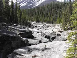 Mistaya River before the falls | |
| Location | |
| Country | Canada |
| Province | Alberta |
| Physical characteristics | |
| Source | |
| • location | Peyto Lake |
| Length | 38 km (24 mi) |
| Basin features | |
| River system | North Saskatchewan River |
Mistaya River originates in Peyto Lake, a glacial lake of typical blue colour (due to rock flour). Mistaya flows north-west, receiving the waters of creeks such as Delta, Silverhorn, Cirque, Noyes, Chephren, Totem, Epaulette, Bison, Kaufmann and Sarbach. A series of elongated lakes are formed along the river: Mistaya Lake and Waterfowl Lakes.
Mistaya merges into the North Saskatchewan River at Saskatchewan River Crossing.
From its headwaters of Peyto Creek, Mistaya River has a total length of 38 km.
The origin of the name is from the Cree language: ᒥᐢᑕᐦᐊᔭ (mistahaya) means "grizzly bear".[1][2][3]
See also
References
- Koller, Brenda (December 2011). The Canadian Rockies Adventure Guide. ISBN 9781588435996.
- Fromhold, Joachim (14 January 2013). 2001 INDIAN PLACE NAMES OF THE WEST, Part 2: Listings by Nation. ISBN 9781300389118.
- "Search results". www.creedictionary.com. Retrieved 2020-11-19.
| Rivers | 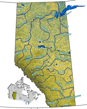 Rivers and lakes in Alberta | |
|---|---|---|
| Waterfalls | ||
| Lakes | ||
| Reservoirs | ||
| Glaciers | ||
| Other | ||
 Rivers portal Rivers portal
 Lakes portal Lakes portal | ||