Interstate 59
Interstate 59 (I-59) is an Interstate Highway located in the southeastern United States. It is a north–south route that spans 445.23 miles (716.53 km) from a junction with I-10 and I-12 at Slidell, Louisiana, to a junction with I-24 near Wildwood, Georgia.
 | ||||||||||||||||
|---|---|---|---|---|---|---|---|---|---|---|---|---|---|---|---|---|
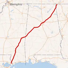 I-59 highlighted in red | ||||||||||||||||
| Route information | ||||||||||||||||
| Length | 445.23 mi[1] (716.53 km) | |||||||||||||||
| Existed | 1960–present | |||||||||||||||
| Major junctions | ||||||||||||||||
| South end |   I-10 / I-12 in Slidell, LA I-10 / I-12 in Slidell, LA | |||||||||||||||
| ||||||||||||||||
| North end |  I-24 near Wildwood, GA I-24 near Wildwood, GA | |||||||||||||||
| Location | ||||||||||||||||
| Country | United States | |||||||||||||||
| States | Louisiana, Mississippi, Alabama, Georgia | |||||||||||||||
| Counties |
| |||||||||||||||
| Highway system | ||||||||||||||||
| ||||||||||||||||
.svg.png.webp)
.svg.png.webp)
.svg.png.webp)


The highway connects the metropolitan areas of New Orleans, Louisiana; Birmingham, Alabama; and Chattanooga, Tennessee, running closely parallel to the older U.S. Route 11 (US 11) corridor for the entire distance. Approximately one-third of the route, spanning 153 miles (246 km) from Meridian, Mississippi, to Birmingham, Alabama, overlaps that of the east–west I-20.
I-59 is a four-lane freeway along its entire route, other than a short stretch extending from north of Tuscaloosa, Alabama, through Birmingham, where it widens to six lanes or more.
Route description
| mi[1] | km | |
|---|---|---|
| LA | 11.48 | 18.48 |
| MS | 171.72 | 276.36 |
| AL | 241.36 | 388.43 |
| GA | 20.67 | 33.27 |
| Total | 445.23 | 716.53 |
Louisiana

I-59 spans 11.48 miles (18.48 km) in Louisiana, the shortest distance in the four states through which it travels. The route begins at a partial cloverleaf interchange with I-10 (exit 267) and I-12 (exit 85) at the northeast corner of Slidell, a city in St. Tammany Parish. From this interchange, connections are made to New Orleans and Hammond, as well as Bay St. Louis, Mississippi. Heading north, I-59 has two exits serving the town of Pearl River, where it begins a concurrency with US 11. Immediately afterward, the highway crosses the West Pearl River and passes through an interchange with Old US 11, a portion of the pre-Interstate alignment serving the Pearl River Wildlife Management Area. I-59 then travels through the Honey Island Swamp for six miles (9.7 km) before crossing the main branch of the Pearl River into Mississippi.[2][3][4]
Mississippi
In Mississippi, I-59 continues to run parallel with US 11, traversing mainly rural areas but going through or bypassing the towns of Picayune, Poplarville, Hattiesburg, Moselle, Ellisville, Laurel, and Meridian.
For its length in Mississippi, I-59 either runs concurrently with, or runs close to, US 11. Between the towns of Pearl River and Picayune, US 11 travels concurrent with I-59. The highway also has concurrencies with US 98 in Hattiesburg; Mississippi Highway 42 (MS 42) just north of Hattiesburg; US 84 and MS 15 in Laurel; and US 80, US 11, and MS 19 in the Meridian area.
A notoriously sharp S-curve, at milepost 96 in Laurel, was the subject of a large reconstruction project that began in 2006. Those sharp curves were the legacy of an overpass over the Southern Railway on a town bypass with design dating from before the Interstate Highways, and they featured a 40-mile-per-hour (64 km/h) speed limit, one of the lowest anywhere on the Interstate Highway System. This work was completed in 2009.[5]
.jpg.webp)
Just west of Meridian, I-20 joins I-59 and these two highways continue together for 145 miles (233 km), across the border with Alabama to and through Birmingham. The exit numbers are given as those of I-59.
At 4:00 pm on August 27, 2005, for the first time in its history, the southbound lanes of I-59 were temporarily redirected northward to accommodate evacuation for Hurricane Katrina. This was a previously agreed to joint plan by the states of Mississippi and Louisiana called contraflow lane reversal. The program began at the Louisiana–Mississippi state line and continued 21 miles (34 km) north to Poplarville.
Alabama
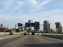
I-59 and I-20 travel together for about 40 percent of their route through Alabama, passing northeast through Tuscaloosa before finally parting ways in eastern Birmingham.
In Birmingham, many wrecks and accidents occur near the crossover interchange of I-20/I-59 and I-65 (commonly called "Malfunction Junction"). On two occasions, 18-wheelers crashed and burned fiercely enough to melt the support beams of overpasses. Beginning in eastern Birmingham, I-59 continues on its own northeast, passing by Gadsden and Fort Payne in the foothills of the Appalachian Mountains before entering Georgia.
I-59 from Gadsden at milemarker 182 to Stephen's Gap at milemarker 193 had degraded over the decades since it was opened into a rough concrete highway. Between 2010 and 2014, a construction project called "Project 59" took place between Gadsden and Fort Payne. This project consisted of reconstructing the Interstate Highway with unbonded concrete (without any space cracks) as well as modifications to the width and vertical clearance of the bridges and overpasses in the segment.
Georgia
I-59 has a short trek through Georgia, with only three exits before ending at I-24 several miles west of Chattanooga, Tennessee, in Wildwood, Georgia. The entire route of I-59 in Georgia is named Korean War Veterans Memorial Highway. I-59's southbound location is marked Birmingham instead of Gadsden in Georgia. Gadsden is the next city that I-59 southbound is traveling to right before the route reaches Birmingham. For services, I-59 has no direct access to the Georgia Welcome Center, instead I-59's Georgia Welcome Center is located in Trenton. Drivers must take I-59 Trenton exit 11 to get access to the Georgia Welcome Center. Within Georgia, it carries unsigned designated as State Route 406 (SR 406) for internal Georgia Department of Transportation (GDOT) purposes.[6]
Exit list
| State | Parish/County | Location | mi[19][20][21] | km | Exit | Destinations | Notes |
|---|---|---|---|---|---|---|---|
| Louisiana | St. Tammany | Slidell | 0.000– 0.842 | 0.000– 1.355 | 1 | I-10 – New Orleans, Bay St. Louis I-12 west – Hammond | Southern terminus of I-59; eastern terminus of I-12; signed as exits 1A (I-12 west), 1B (I-10 east), and 1C (I-10 west); I-10 exit 267; I-12 exit 85 |
| | 3.424– 4.156 | 5.510– 6.688 | 3 |  .svg.png.webp) US 11 south / LA 1090 south – Pearl River US 11 south / LA 1090 south – Pearl River | Southern end of US 11 concurrency; northern terminus of LA 1090 | ||
| Pearl River | 5.170– 5.636 | 8.320– 9.070 | 5A | .svg.png.webp) LA 3081 – Pearl River LA 3081 – Pearl River | Northern terminus of LA 3081 | ||
| | 6.264– 6.765 | 10.081– 10.887 | 5B | Honey Island Swamp | To Old US 11 | ||
| | 11.638– 11.957 | 18.730– 19.243 | 11 | Pearl River Turnaround | |||
| Pearl River | 12.058 0.0 | 19.405 0.0 | Louisiana–Mississippi state line | ||||
| Mississippi | Pearl River | | 0.5 | 0.80 | 1 |  US 11 north / MS 607 south – Nicholson, NASA John C. Stennis Space Center US 11 north / MS 607 south – Nicholson, NASA John C. Stennis Space Center | North end of US 11 concurrency |
| Picayune | 4.0 | 6.4 | 4 |  MS 43 south – Picayune, Kiln MS 43 south – Picayune, Kiln | South end of MS 43 concurrency | ||
| 6.0 | 9.7 | 6 | MS 43 north – North Picayune | North end of MS 43 concurrency | |||
| | 10.5 | 16.9 | 10 | Carriere | |||
| | 14.9 | 24.0 | 15 | McNeill | |||
| | 19.5 | 31.4 | 19 | Millard | |||
| | 26.7 | 43.0 | 27 |  MS 53 – Necaise, Poplarville MS 53 – Necaise, Poplarville | |||
| | 29.6 | 47.6 | 29 |  MS 26 – Poplarville, Wiggins MS 26 – Poplarville, Wiggins | |||
| | 35.4 | 57.0 | 35 | Hillsdale Road | |||
| Lumberton | 41.1 | 66.1 | 41 |  MS 13 – Lumberton MS 13 – Lumberton | |||
| Lamar | Purvis | 51.3 | 82.6 | 51 |  MS 589 – Purvis MS 589 – Purvis | ||
| Forrest | | 58.6 | 94.3 | 59 |  US 98 east – Lucedale, Mobile US 98 east – Lucedale, Mobile | South end of US 98 concurrency | |
| | 60.5 | 97.4 | 60 | US 11 – South Hattiesburg, Downtown Hattiesburg | |||
| Lamar | Hattiesburg | 64.8 | 104.3 | 65 | US 98 west (MS 198 east) / Hardy Street – Columbia | North end of US 98 concurrency; signed as exits 65A (MS 198) and 65B (US 98) northbound | |
| Forrest | 67.4 | 108.5 | 67 |   US 49 / MS 42 west – Hattiesburg, Jackson US 49 / MS 42 west – Hattiesburg, Jackson | South end of MS 42 concurrency; signed as exits 67A (south) and 67B (north) | ||
| 69.6 | 112.0 | 69 | MS 42 east (Evelyn Gandy Parkway) – Petal | North end of MS 42 concurrency | |||
| | 73.1 | 117.6 | 73 | Monroe Road | |||
| Jones | | 75.6 | 121.7 | 76 | Hattiesburg-Laurel Regional Airport | ||
| | 78.0 | 125.5 | 78 | Sanford Road | |||
| | 80.3 | 129.2 | 80 | Moselle | |||
| | 85.6 | 137.8 | 85 |  MS 590 – Ellisville MS 590 – Ellisville | |||
| Ellisville | 88.2 | 141.9 | 88 |   MS 29 / MS 588 – Ellisville MS 29 / MS 588 – Ellisville | |||
| | 90.3 | 145.3 | 90 | US 11 (Ellisville Boulevard) | |||
| Laurel | 92.9 | 149.5 | 93 | US 11 – South Laurel | |||
| 94.5 | 152.1 | 95 |   US 84 west / MS 15 north (16th Avenue) US 84 west / MS 15 north (16th Avenue) | South end of US 84/MS 15 concurrency; signed as exits 95A (south) and 95B (north) | |||
| 95.0 | 152.9 | 95C | Beacon Street | Laurel S-curve southbound | |||
| 95.6 | 153.9 | 96A | 4th Avenue, Masonite Road | ||||
| 96.0 | 154.5 | 96B | MS 15 south (Cook Avenue) – Richton | North end of MS 15 concurrency | |||
| 96.8 | 155.8 | 97 | US 84 east (Chantilly Street) – Waynesboro | North end of US 84 concurrency | |||
| 98.6 | 158.7 | 99 | US 11 | ||||
| | 104.1 | 167.5 | 104 | Sandersville | |||
| Jasper | | 113.3 | 182.3 | 113 |  MS 528 – Heidelberg, Bay Springs MS 528 – Heidelberg, Bay Springs | ||
| | 118.2 | 190.2 | 118 | Vossburg, Paulding | |||
| Clarke | | 125.9 | 202.6 | 126 |  MS 18 – Rose Hill, Pachuta MS 18 – Rose Hill, Pachuta | ||
| | 133.6 | 215.0 | 134 |  MS 513 – South Enterprise, Rose Hill MS 513 – South Enterprise, Rose Hill | Rose Hill not on northbound sign | ||
| | 136.8 | 220.2 | 137 | North Enterprise | |||
| Lauderdale | | 141.6 | 227.9 | 142 | Savoy | ||
| | 147.9 | 238.0 | 149 |   I-20 west / US 80 west – Jackson I-20 west / US 80 west – Jackson | South end of I-20/US 80 concurrency | ||
| Meridian | 149.9 | 241.2 | 150 |  US 11 south / MS 19 north – Philadelphia, Meridian Airport US 11 south / MS 19 north – Philadelphia, Meridian Airport | South end of US 11/MS 19 concurrency | ||
| 150.5 | 242.2 | 151 | Valley Road, 49th Avenue | ||||
| 151.4 | 243.7 | 152 | 29th Avenue | ||||
| 152.8 | 245.9 | 153 |   MS 145 south / MS 493 north (22nd Avenue) – Quitman MS 145 south / MS 493 north (22nd Avenue) – Quitman | ||||
| 153.7 | 247.4 | 154 |  US 11 north / US 80 east / MS 19 south / MS 39 north – De Kalb, Butler US 11 north / US 80 east / MS 19 south / MS 39 north – De Kalb, Butler | North end of US 11/US 80/MS 19 concurrency; signed as exits 154A (south) and 154B (north) northbound | |||
| 155.4 | 250.1 | 156 | Jimmie Rodgers Pkwy | ||||
| 156.5 | 251.9 | 157 |  US 45 – Quitman, Macon US 45 – Quitman, Macon | Signed as exits 157A (south) and 157B (north) | |||
| | 160.0 | 257.5 | 160 | Russell | |||
| | 164.6 | 264.9 | 165 | Toomsuba | |||
| | 168.2 | 270.7 | 169 | US 11 / US 80 – Kewanee | |||
| 171.7 0.0 | 276.3 0.0 | Mississippi–Alabama state line | |||||
| Alabama | Sumter | | 0.804 | 1.294 | 1 |  To US 80 east – Cuba, Demopolis To US 80 east – Cuba, Demopolis | |
| | 3 |  I-85 north – Montgomery I-85 north – Montgomery | Proposed interchange; future southern terminus of I-85 | ||||
| | 8.041 | 12.941 | 8 |  SR 17 – York SR 17 – York | |||
| | 17.059 | 27.454 | 17 |  SR 28 – Livingston, Boyd SR 28 – Livingston, Boyd | |||
| | 23.141 | 37.242 | 23 |  CR 20 – Gainesville, Epes CR 20 – Gainesville, Epes | |||
| Greene | | 32.229 | 51.868 | 32 | Boligee | ||
| | 40.766 | 65.607 | 40 |  SR 14 – Aliceville, Eutaw SR 14 – Aliceville, Eutaw | |||
| | 45.334 | 72.958 | 45 | Union | |||
| | 52.244 | 84.079 | 52 |  US 11 / US 43 – Knoxville US 11 / US 43 – Knoxville | |||
| Tuscaloosa | | 62.466 | 100.529 | 62 |  SR 300 – Fosters SR 300 – Fosters | SR 300 is an unsigned route | |
| Tuscaloosa | 68.083 | 109.569 | 68 | Northport Tuscaloosa Western Bypass | |||
| 71.367 | 114.854 | 71 |   I-359 north / SR 69 – Tuscaloosa, Moundville I-359 north / SR 69 – Tuscaloosa, Moundville | Signed as exits 71A (south) and 71B (north); unsigned US 11 | |||
| 73.003 | 117.487 | 73 |  US 82 (McFarland Boulevard) US 82 (McFarland Boulevard) | ||||
| 75.961 | 122.247 | 76 | US 11 (Skyland Boulevard) | ||||
| 77.102 | 124.084 | 77 | Buttermilk Road | ||||
| | 79.895 | 128.579 | 79 | US 11 – Tuscaloosa, Coaling | |||
| | 86.295 | 138.878 | 86 | Brookwood, Vance | |||
| | 89.253 | 143.639 | 89 | Mercedes Drive | |||
| | 97.138 | 156.328 | 97 |  US 11 south / SR 5 south – West Blocton, Centreville US 11 south / SR 5 south – West Blocton, Centreville | South end of US 11/SR 5 concurrency | ||
| | 100.292 | 161.404 | 100 | Abernant, Bucksville | Unsigned eastern terminus for SR 216 | ||
| Jefferson | | 104.159 | 167.628 | 104 | Rock Mountain Lake | McAshan Drive | |
| | 106.201 | 170.914 | 106 |   I-422 north / I-459 north – Gadsden, Montgomery, Atlanta I-422 north / I-459 north – Gadsden, Montgomery, Atlanta | Proposed interchange; southern terminus of I-459; future southern terminus of I-422 | ||
| Bessemer | 108.396 | 174.446 | 108 | US 11 north / SR 5 north (Academy Drive) | North end of US 11/SR 5 concurrency | ||
| 110.021 | 177.062 | 110 | Splash Adventure Parkway | ||||
| 112.341 | 180.795 | 112 | 18th Street, 19th Street | ||||
| 113.280 | 182.306 | 113 | 18th Avenue | ||||
| 115.520 | 185.911 | 115 | Allison–Bonnet Memorial Drive, Jaybird Road | ||||
| Fairfield | 118.304 | 190.392 | 118 | Valley Road – Fairfield | |||
| Birmingham | 119.025 | 191.552 | 119 | Lloyd Noland Parkway | Signed as exit 119A southbound | ||
| 119.727 | 192.682 | 119B | Avenue I | Southbound exit and northbound entrance | |||
| 120.934 | 194.624 | 120 |  SR 269 (20th Street) / Ensley Avenue SR 269 (20th Street) / Ensley Avenue | Southern terminus of SR 269 | |||
| 121.238 | 195.114 | 121 | Bush Boulevard | Southbound exit and northbound entrance | |||
| 123.374 | 198.551 | 123 |  US 78 (Arkadelphia Road) – Jasper US 78 (Arkadelphia Road) – Jasper | Unsigned SR 5 | |||
| 124.740 | 200.750 | 124 A-B |  I-65 – Montgomery, Huntsville I-65 – Montgomery, Huntsville | Signed as exits 124A (south) and 124B (north); hybrid interchange | |||
| 124.740 | 200.750 | 124 C | 17th Street – Downtown Birmingham | Interchange incorporated into Malfunction Junction; former exit removed | |||
| 125.639 | 202.196 | 125 | 22nd Street – Downtown Birmingham | Signed as exit 125 southbound | |||
| 126.239 | 203.162 | 126A |   US 31 / US 280 east / Carraway Boulevard – Civic Center US 31 / US 280 east / Carraway Boulevard – Civic Center | Western terminus of US 280 | |||
| 126.825 | 204.105 | 126B | 31st Street North | ||||
| 128.257 | 206.410 | 128 |  SR 79 (Tallapoosa Street) SR 79 (Tallapoosa Street) | ||||
| 129 | Airport Boulevard | ||||||
| 130.301 | 209.699 | 130 | I-20 east – Atlanta | North end of I-20 concurrency | |||
| 131.801 | 212.113 | 131 | Oporto–Madrid Boulevard | Northbound exit and southbound entrance | |||
| 132.214 | 212.778 | 132 | US 11 (1st Avenue North) | No access from I-59 north to US 11 south, from US 11 south to I-59 north, or from US 11 north to I-59 south | |||
| 133.814 | 215.353 | 133 | 4th Avenue South | Northbound exit and southbound entrance | |||
| 134.383 | 216.268 | 134 |  To SR 75 (Roebuck Parkway) – Center Point, Tarrant, Oneonta To SR 75 (Roebuck Parkway) – Center Point, Tarrant, Oneonta | ||||
| Trussville | 137.202 | 220.805 | 137 | I-459 south – Montgomery, Tuscaloosa, Atlanta | Northern terminus of I-459 | ||
| 140.802 | 226.599 | 141 | Trussville, Pinson | ||||
| | 143.647 | 231.177 | 143 | Deerfoot Parkway, Mount Olive Church Road | |||
| | 147 | I-422 south | Proposed interchange; future northern terminus of I-422 | ||||
| | 147.647 | 237.615 | 148 | To US 11 – Argo | |||
| Saint Clair | | 153.911 | 247.696 | 154 |  SR 174 – Odenville, Springville SR 174 – Odenville, Springville | ||
| | 156.178 | 251.344 | 156 |  SR 23 – Springville, Ashville, St Clair Springs SR 23 – Springville, Ashville, St Clair Springs | |||
| | 166.322 | 267.669 | 166 |  US 231 – Ashville, Oneonta US 231 – Ashville, Oneonta | |||
| | 173.650 | 279.463 | 174 | Steele | |||
| Etowah | Attalla | 181.294 | 291.764 | 181 |  SR 77 – Attalla, Rainbow City SR 77 – Attalla, Rainbow City | ||
| 182.058 | 292.994 | 182 |  I-759 east – Gadsden I-759 east – Gadsden | Western terminus of I-759 | |||
| 183.030 | 294.558 | 183 |   US 278 (SR-74) / US 431 (SR-1/5th Avenue) – Attalla, Gadsden US 278 (SR-74) / US 431 (SR-1/5th Avenue) – Attalla, Gadsden | ||||
| Gadsden | 188.082 | 302.689 | 188 |  SR 211 to US 11 – Noccalula Falls Park SR 211 to US 11 – Noccalula Falls Park | |||
| DeKalb | | 205.148 | 330.154 | 205 |  SR 68 – Collinsville, Crossville SR 68 – Collinsville, Crossville | ||
| | 218.654 | 351.890 | 218 |  SR 35 – Fort Payne, Rainsville SR 35 – Fort Payne, Rainsville | |||
| | 222.152 | 357.519 | 222 | US 11 – Fort Payne | |||
| | 224.100 | 360.654 | 224 | 49th Street | |||
| | 231.419 | 372.433 | 231 |   SR 40 / SR 117 – Valley Head, Hammondville SR 40 / SR 117 – Valley Head, Hammondville | |||
| | 239.642 | 385.666 | 239 | To US 11 / Sulphur Springs Road | |||
| 241.179 0.0 | 388.140 0.0 | Alabama–Georgia state line | |||||
| Georgia | Dade | | 4.1 | 6.6 | 4 | Deer Head Cove Road - Rising Fawn | Old exit 1 |
| Trenton | 11.5 | 18.5 | 11 |  SR 136 – Trenton SR 136 – Trenton | To the Georgia Welcome Center and to the Cloudland Canyon State Park; old exit 2 | ||
| | 17.3 | 27.8 | 17 | Slygo Road – New England | Old exit 3 | ||
| | 19.5 | 31.4 | — | I-24 (SR 409) – Nashville, Chattanooga | Northern terminus; northbound exit and southbound entrance; I-24 exit 167 | ||
1.000 mi = 1.609 km; 1.000 km = 0.621 mi
| |||||||
Auxiliary routes
See also
 U.S. roads portal
 Mississippi portal
.svg.png.webp) Georgia (U.S. state) portal
Georgia (U.S. state) portal
References
- "Table 1: Main Routes of the Dwight D. Eisenhower National System of Interstate and Defense Highways as of December 31, 2016". Route Log and Finder List. Federal Highway Administration. February 22, 2017. Retrieved May 14, 2017.
- Google (May 14, 2017). "Overview Map of I-59 in Louisiana" (Map). Google Maps. Google. Retrieved May 14, 2017.
- Louisiana Department of Transportation and Development Office of Multimodal Planning (February 2012). St. Tammany Parish (East Section) (PDF) (Map). Louisiana Department of Transportation and Development. Retrieved May 14, 2017.
- Louisiana Department of Transportation and Development Office of Multimodal Planning (February 2012). District 62: Official Control Section Map / Construction and Maintenance (PDF) (Map). Louisiana Department of Transportation and Development. Retrieved May 14, 2017.
- Richardson, Ontario (September 11, 2009). "Laurel S-Curve renamed, reopened". WDAM-TV. Retrieved September 27, 2020.
- Office of Transportation Data (2003). Interstate Mileage Report (438 Report) (PDF). Georgia Department of Transportation. Archived from the original (PDF) on February 18, 2006.
- Federal Highway Administration (May 8, 2019). National Highway System: Louisiana (PDF) (Map). Federal Highway Administration. Retrieved August 15, 2019.
- Federal Highway Administration (May 9, 2019). National Highway System: Slidell, LA (PDF) (Map). Federal Highway Administration. Retrieved August 15, 2019.
- Federal Highway Administration (May 8, 2019). National Highway System: Mississippi (PDF) (Map). Federal Highway Administration. Retrieved August 15, 2019.
- Federal Highway Administration (May 9, 2019). National Highway System: Hattiesburg, MS (PDF) (Map). Federal Highway Administration. Retrieved August 15, 2019.
- Federal Highway Administration (May 9, 2019). National Highway System: Laurel (PDF) (Map). Federal Highway Administration. Retrieved August 15, 2019.
- Federal Highway Administration (May 9, 2019). National Highway System: Meridian (PDF) (Map). Federal Highway Administration. Retrieved August 15, 2019.
- Federal Highway Administration /alabama/al_alabama.pdf (May 8, 2019). National Highway System: Alabama (Map). Federal Highway Administration. Retrieved August 15, 2019.
- Federal Highway Administration (May 9, 2019). National Highway System: Tuscaloosa, AL (PDF) (Map). Federal Highway Administration. Retrieved August 15, 2019.
- Federal Highway Administration (May 9, 2019). National Highway System: Birmingham, AL (PDF) (Map). Federal Highway Administration. Retrieved August 15, 2019.
- Federal Highway Administration (May 9, 2019). National Highway System: Gadsden, AL (PDF) (Map). Federal Highway Administration. Retrieved August 15, 2019.
- Federal Highway Administration (May 8, 2019). National Highway System: Georgia (PDF) (Map). Federal Highway Administration. Retrieved August 15, 2019.
- Federal Highway Administration (May 10, 2019). National Highway System: Chattanooga, TN–GA (PDF) (Map). Federal Highway Administration. Retrieved August 15, 2019.
- "La DOTD GIS Data". Louisiana Department of Transportation and Development. September 2015. Retrieved May 14, 2017.
- "Milepost Web". October 27, 2016.
- "Overview Map of Interstate 59 in Georgia". Google Maps. Retrieved September 12, 2016.
External links
 Media related to Interstate 59 at Wikimedia Commons
 Primary Interstate Highways Primary Interstate Highways | |
|---|---|
| Signed | |
| Unsigned | |
| Lists | |
| Other | |
Major Interstates highlighted | |