Balnakeil
Balnakeil is a hamlet in the parish of Durness, Sutherland,[1] Scottish Highlands, and is in the Scottish council area of Highland. It is on the north coast of Scotland around 3⁄4 mile (1.2 kilometres) northwest of Durness. The ruins of Balnakeil Church are a scheduled monument. The Kyle of Durness is west of Balnakeil which gives its name to the 2-mile-wide (3-kilometre) Balnakeil Bay which the Kyle opens into.[2]
Balnakeil
| |
|---|---|
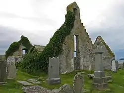 Ruined church at Balnakeil | |
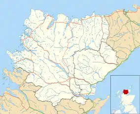  Balnakeil Location within the Sutherland area | |
| OS grid reference | NC394678 |
| Council area | |
| Lieutenancy area | |
| Country | Scotland |
| Sovereign state | United Kingdom |
| Post town | Durness |
| Postcode district | IV27 4 |
| Police | Scotland |
| Fire | Scottish |
| Ambulance | Scottish |
The peninsula of Faraid Head is to the north of Balnakeil. It was the site of a 1950s radar station and remains the range control for Ministry of Defence bombing operations in the Cape Wrath Training Area to the west.[3]
Three small lochs are to the south of Balnakeil: Loch Croispol, Loch Borralie and Loch Caladail. Durness Golf Course is to the southwest.[4]
See also
References
- Microsoft; Nokia (20 April 2017). "Balnakeil" (Map). Bing Maps. Microsoft. Retrieved 20 April 2017.
- Groome.F.H (1885) 'Parish of Durness', Ordnance Gazetteer of Scotland: A Survey of Scottish Topography, Statistical, Biographical and Historical, (available online). Retrieved 2013-02-20.
- RAF Faraid Head ('RAI') CEW R10 ROTOR Radar station, Subterranea Britannica, 2004-06-15. Retrieved 2013-02-20.
- Loch Borralie, Kyle of Durness, Historic Scotland, 2003. Retrieved 2013-02-20.
 |
Wikimedia Commons has media related to Balnakeil. |